Map

The background Map is composed of multiple images (known as Map Tiles) that are stitched together into a continuous and seamless map. The sample image to the right is composed of 8 Map Tiles.
These Map Tiles are retrieved from the configured Map Server as required for the displayed Route. KayakNav only ever downloads a map tile once and it stores it into an internal database automatically. The more you use KayakNav, the more map tiles will be cached in this database. The map can be displayed much more quickly from cached tiles than from the map server.
The map displayed in KayakNav is actually a square map that faces North and extends beyond the bounds of your display. The square map is rotated on the device match your current bearing and the orientation of the device (i.e. portrait or landscape). This image rotation is remarkably fast due to hardware graphics acceleration. When the map is panned, more map tiles are added to one side of the map and released from the other side. Zooming the map just fetches Map Tiles at a different resolution and displays these.
The Map and overlaid Info Cells and Annotations are updated automatically every 3 seconds or immediately if the bearing has changed by more than 5 degrees.
If Map Tiles for the required zoom level are not currently available, KayakNav will attempt to use a lower resolution tile if it is available. This may appear as blurred section on the map. The correct tile will be fetched automatically.
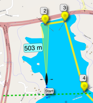
The Route is drawn over the top of the map as a series of solid and dashed coloured lines. These lines pass through labelled Waypoints and Turning Points along the route. Bisect Lines are also drawn through the Turning Points to show where you are deemed to have passed that point.
The Animated Paddler Icon and the Virtual Training Partner icon are drawn over the other symbols to indicate their current position on the map.
A Targeting Beam that looks like a yellow torch light is shown from the Animated Paddler Icon to the next Target Waypoint with a distance to that point.
All of the configured translucent Info Cells are drawn over the top of all the other information to allow data to be presented to the paddler in real time. This includes over 100 Data Items.